Learning landscapes
Freiburg, Nov 28, 2018
Photo: Patrick Seeger
An app has been developed at the University of Freiburg that provides scientific information at so-called learning locations throughout the city. Students can supplement and deepen their knowledge there. Four environmental science students recently tested the app.
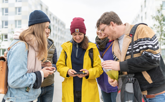
Students can receive expert information through the app at so-called learning locations. Photos: Patrick Seeger
A cool and cloudy Wednesday in October. A small group has gathered at the University of Freiburg Faculty of Engineering. Hands are shaken. Greetings are shared. Then as if on que, everyone pulls out their smartphone. 2 p.m. Are you ready? Of course, the simultaneous view of the device is more than a simple clock check. All five group members look to see if they can start the learning location app they downloaded earlier.
Staff from the Chair of Remote Sensing, the University of Freiburg IT Services and an external software company developed the app. Sebastian Brackhane, research assistant from the Chair of Remote Sensing coordinated the project. Today he is helping four environmental science students become more familiar with the learning location app, which is still in the beta phase. “We have termed the concept ‘science trails’,” explains Brackhane. “The idea is to be outdoors in the field – and to receive expert information through the app to help people get a handle on a certain topic.”
Relief for lecturers
It has long been known that concrete on-site observation is excellently suited to expanding and deepening acquired knowledge. Thanks to the app, students can carry out such on-site excursions independently without any academic support. “This frees up the lecturers’ time and helps them to concentrate on other aspects of teaching,” says Brackhane. “And in this way, students are not tied to yet another fixed date and can organize their learning workload more individually.”
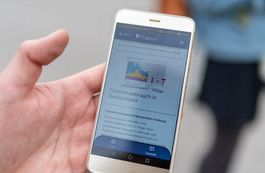
An introductory text, graphics and aerial photographs show the on-site development at the Freiburg airport over the past few decades.
The app starts without any problems. “That’s good,” mumbles Brackhane. Yesterday he was in Basel where the app still had a few snags - it is being further developed with funding from the trinational network EUCOR - The European Campus so that in future it can also be used at learning locations in France and Switzerland. Johannes Jung, one of the four environmental scientists, is now taking a look at the app. A map becomes visible: the Faculty of Engineering and a blue dot in front of it, which marks the group’s location. Not far away towards the airfield, you can see their destination in orange, the learning location of the excursion. “But I can't get any more information on the display,” remarks Jung. Of course, it is not a shortcoming, but intentional, as Brackhane knows: “The subject content only appears when you are within 200 meters of the respective learning location,” he says with a smile. The technical trick ensures that students really do embark on their little journey - instead of trying to deepen and supplement their knowledge from the comfort of their own couch at home.
Defining individual learning locations
The group starts to meander across the campus in the direction of the airfield. As soon as the students have walked a few meters, the contents appear on the app. So far, there are twelve learning locations for the app. For example, the cathedral, where geology students learn about sandstone as a building material. The subject content for this learning location was developed by the Chair of Mineralogy and Petrology, which was involved in the development of the concept together with the Chair of Remote Sensing, Physical Geography and the Chair of Prehistoric and Early Historical Archaeology. Starting this semester, each subject at the University of Freiburg has been able to define its own learning locations for the app and independently create the learning content. “This works via the central ILIAS learning platform from IT Services,” says Brackhane.
The airport as a learning location is about land consumption: a huge topic, especially in metropolitan areas such as Freiburg. An introductory text appears on the app, supplemented by graphics and aerial photographs showing the on-site developments over the past few decades. The group is standing at one of the fastest growing points in Freiburg that was once wasteland. In addition to the convention center, the University and associated institutes, SC Freiburg will soon be contributing to the area - the new stadium is being built just around the corner. The last aerial photo of the app is from 2013 and shows three blocks of flats with dorms for Faculty of Engineering students. When you take your eyes off your smartphone and look around, you notice: There are now six of them.
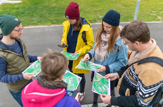
In order to be able to calculate the area later, the students enter the GPS data of the new buildings into a map.
Today, land consumption is often measured by remote sensing. For example, by means of satellite images that are evaluated on the computer. The on-site exercise also serves to familiarize students with such methods. Just like its historical predecessors - surveying on site. That's why a practical task is now on the agenda. The four students are to measure how much land has been used by the three new buildings that have been erected here since 2013. The students record the position of the corner points of these buildings using the GPS coordinates they have determined with their mobile phones. In order to be able to calculate the area later, they enter the coordinates into a large scale copied map distributed by Brackhane. “So we can also do old school,” notes the student Kirja Kajewski jokingly and raises her pen to prove it.
Athletic knowledge acquisition
The four of them move around the houses, from corner point to corner point, sometimes applying a certain level of athleticism. Because Heidrun Irion can’t get a GPS signal, she has to climb onto a wall with her arm outstretched. Then they out their heads together, hovering over the map as they begin to count and laugh. “In addition to such exercises, other forms of knowledge transfer are also conceivable,” comments Brackhane. For instance, a small multiple choice quiz. And of course the app could not only be equipped with text and image files, but also with audio material. For example, if the app is aimed at students with impaired eyesight: “The app should make the learning locations as barrier-free as possible.”
As the excursion comes to a close, Brackhane asks for feedback: What else could be changed, improved? Irion remarks that the GPS signal was not accurate, which falsified the result. Brackhane nods, but also sees this as an important learning result: “Remote sensing can be significantly faster and more precise.” Jung believes that the font size could be freely selectable in terms of accessibility. Kirsi Schmidt found the task in the accompanying text imprecise, leaving room for interpretation. But these are small things that can be changed quickly. In general, the four students are satisfied with the technology and can well imagine further applications, in soil science for example. Finally, Kajewski praises the intuitive structure of the app. “A tram ride was enough for me to familiarize myself with it.”
Mathias Heybrock